
If 3D laser scanning is the process of capturing reality, then the point cloud is what you get at the end of it.
It’s the part most people don’t see or understand at first but it’s also the most important piece of the puzzle. Everything that comes after a laser scan (drawings, models, BIM, analysis) starts here.
So, what is a point cloud?
A point cloud is a large collection of individual measurement points that together represent a real-world space in 3D.
Each point is essentially a single “pin” in space with a precise location:
- Left/right position (X)
- Forward/back position (Y)
- Height (Z)
Put millions or even billions of these points together and you start to rebuild the shape of the real world digitally.
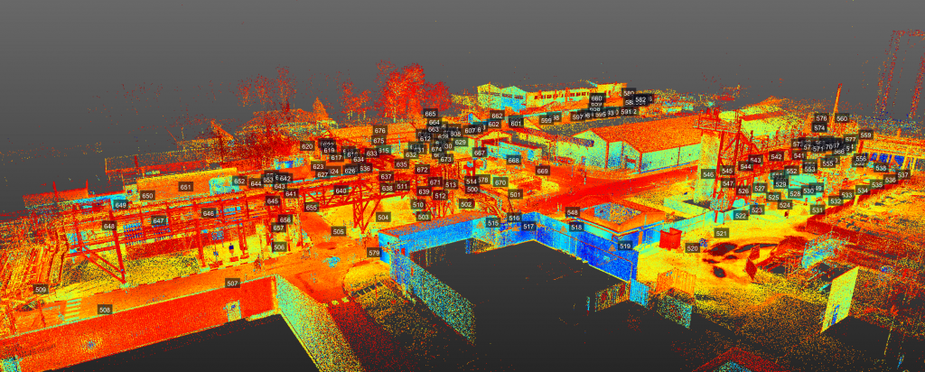
At first glance it can look like a chaotic cloud of dots, hence the name. But once you understand what you’re looking at it becomes surprisingly intuitive. Walls appear. Floors become flat planes. Pipes and structures start to take shape.
It’s not a drawing or a model in the traditional sense. It’s closer to a digital imprint of reality.
How is a point cloud created?
A point cloud is created directly from the laser scanning process.
When a scanner is set up on site it sends out a laser beam that hits surrounding surfaces and returns to the device. The scanner measures how far away each surface is based on how long that laser takes to come back.
This happens millions of times extremely quickly, from one or more scanner positions.
Every single measurement becomes a point in space. Once all those points are combined, you get the full point cloud.
If you imagine it visually, it’s a bit like:
- Taking a photograph of a space
- But instead of pixels with colour, you get points with position
- And instead of a flat image, you get full 3D depth
Why is a point cloud useful?
On its own a point cloud doesn’t look like much to a beginner. It can feel overwhelming, almost like digital noise.
But for engineers, designers and surveyors it’s incredibly powerful because it contains the exact geometry of the real world.
From a point cloud, you can:
- Measure distances accurately
- Extract floor plans and sections
- Create 3D CAD models
- Check what exists on site before designing anything new
- Compare “as-built” conditions against original design drawings
It’s basically a reliable reference of reality that you can keep going back to.
What does a point cloud actually look like?
If you open a point cloud file on a computer, the first impression can be a bit underwhelming. It often looks like a grey or coloured cloud of dots with no clear structure.
But as you zoom in and navigate around it, things start to make sense.
You’ll begin to see:
- Walls forming flat vertical surfaces
- Floors appearing as solid horizontal planes
- Pipes becoming clear cylindrical shapes
- Equipment and structures becoming recognisable objects
With enough data density, it can feel almost like you’re moving through a real space — just in digital form.
Some point clouds are also coloured using photographs captured during the scan, which makes them much easier to interpret visually.
Types of point cloud data
Not all point clouds are exactly the same. Depending on how they were captured and processed they can vary quite a bit.
In general, you’ll come across:
Raw scan data
This is the initial data directly from the scanner. It’s usually separated into multiple scan positions and needs processing before it becomes usable.
Registered point clouds
This is when multiple scans have been aligned together into a single coordinated dataset. At this stage, everything fits together into one consistent 3D environment.
Classified or processed point clouds
In more advanced workflows, the data may be further processed so that different elements are identified: for example walls, floors, pipes, or equipment.
This is where point clouds start moving closer to structured models and BIM workflows.
How is a point cloud used in real projects?
The real value of a point cloud comes after capture.
Once the data has been processed it becomes a foundation for design and engineering work.
In construction it might be used to measure an existing building before renovation work begins. Instead of relying on old drawings that may no longer be accurate teams can work directly from the scanned reality.
In industrial environments point clouds are often used to design new pipework or equipment layouts. Engineers can check exactly how much space is available before anything is installed.
In marine and offshore work they’re essential for understanding complex spaces like engine rooms or platform topsides, where geometry is tight and constantly changing.
Across all industries the key idea is the same: you are working from reality, not assumptions.
Why not just use drawings?
This is a common question, especially from people new to the technology.
Traditional drawings are useful, but they often represent how something was designed, not how it exists today.
Buildings and industrial sites change over time. Things get modified, moved, replaced, or added. Over years of maintenance and upgrades, the real-world environment can end up quite different from the original design documentation.
A point cloud removes that uncertainty because it captures the current physical state of the asset exactly as it is.
What are the limitations?
Point clouds are powerful but they’re not perfect.
Because they contain such a large amount of data they can be heavy to work with. Large industrial sites can generate files that are tens or even hundreds of gigabytes in size, which requires strong hardware and careful data management.
They also require interpretation. While a trained engineer can quickly read a point cloud a beginner might find it confusing at first.
And finally, they still depend on good scanning practice. If something wasn’t captured properly on site it won’t appear in the data.
Why point clouds matter so much
The easiest way to think about a point cloud is this:
It is the closest thing we currently have to a perfect digital copy of the physical world.
It doesn’t simplify reality. It doesn’t interpret it. It just captures it as it is.
That’s why it has become such a fundamental part of modern engineering, construction and design workflows.
Once you have accurate reality captured everything else becomes easier, planning, designing, building, and maintaining.
Final thoughts
A point cloud might look like just a cloud of dots at first but it represents something much more important: a complete, measurable digital version of the real world.
It bridges the gap between physical spaces and digital design tools allowing engineers and designers to work with real conditions instead of assumptions.
And once you understand that it becomes clear why point clouds are at the heart of 3D laser scanning.
If you’re planning a project and need accurate, real world data from the start, contact our team to discuss how 3D laser scanning can help.